Back کوتو د کازا، کالیفورنیا AZB Coto de Caza Catalan Кото-де-Каса (Калифорни) CE Coto De Caza CEB Coto de Caza German Coto de Caza (California) Spanish Coto de Caza (Kalifornia) Basque کوتو د کازا، کالیفرنیا Persian Coto de Caza Finnish Coto de Caza French
Coto de Caza, California | |
|---|---|
 Coto de Caza in 2016 | |
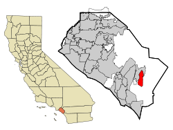
 Location of Coto de Caza within Orange County, California. | |
| Coordinates: 33°35′45″N 117°35′16″W / 33.59583°N 117.58778°W | |
| Country | |
| State | |
| County | Orange |
| Area | |
| • Total | 7.82 sq mi (20.26 km2) |
| • Land | 7.80 sq mi (20.20 km2) |
| • Water | 0.02 sq mi (0.06 km2) 0.29% |
| Elevation | 709 ft (216 m) |
| Population (2020) | |
| • Total | 14,710 |
| • Density | 1,886.38/sq mi (728.36/km2) |
| Time zone | UTC-8 (PST) |
| • Summer (DST) | UTC-7 (PDT) |
| ZIP code | 92679 |
| Area code | 949 |
| FIPS code | 06-16580 |
| GNIS feature IDs | 1867008, 2407666 |
| Website | community |
Coto de Caza (Spanish for "Hunting Reserve") is a census-designated place (CDP) and guard-gated private community in Orange County, California, United States. The population was 14,710 at the 2020 census.
The CDP is a suburban planned community of about 4,000 homes and one of Orange County's oldest and most expensive master-planned communities. The project began in 1968, when it was envisioned as a hunting lodge, now the Lodge at Coto de Caza, and the community was completed in 2003. Coto de Caza also includes Los Ranchos Estates, a 355-acre rural community of 75 large custom homes. Los Ranchos Estates is a separate private community behind the gates of Coto de Caza and has its own homeowner's association.
- ^ "2020 U.S. Gazetteer Files". United States Census Bureau. Retrieved October 30, 2021.
- ^ "Coto De Caza". Geographic Names Information System. United States Geological Survey, United States Department of the Interior. Retrieved October 18, 2014.